A wise man once said that "history doesn't exist until it is written down." This web site is an attempt to gather together evidence which would otherwise be lost about one small part of the English countryside.
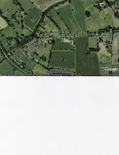
Weaste Lane runs along the southern border of the parish of Thelwall in Cheshire from the junction with Booths Lane to the boundary of Grappenhall parish at Cliff Lane.
As shown in early cottage rent books and historic maps, it was originally called "Waste Lane" and this pronunciation is still used by old residents.
In medieval times the term "waste" referred to land which was outside the cultivated area or parish boundary and therefore had no owner. This seems to be appropriate as the lane well away from the centre of the village and still has open fields to the south which have escaped modern development.
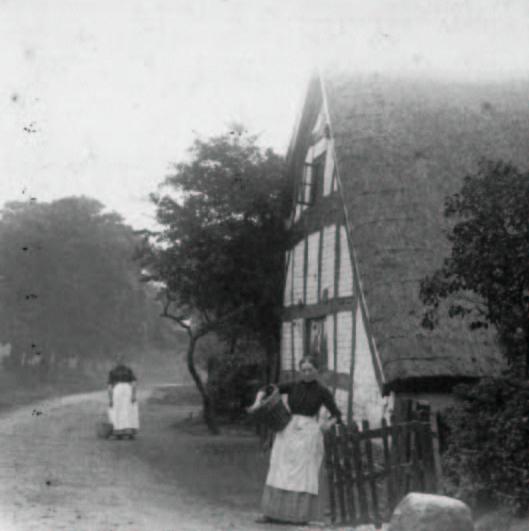
As this is an agricultural area the lane has five farms along its length, some of which have been converted for other purposes. The oldest of these was called Garland Hall in times gone by but, at the time of its demolition was the farmhouse lived in by the Stubbs family, well known farmers in the area.
It was constructed with massive wooden beams in a general style similar to the ancient Pickering Arms in the centre of the Thelwall village. The walls between the beams were yellow and my impression of them was that they were original wattle and daub. This would seem to mean that Weaste Lane was at least as old as the early eighteenth century and probably earlier.
It remained a trackway connecting the farms for many years until Francis Edgerton Third Duke of Bridgewater engaged James Brindley to extend his canal system from Manchester to Runcorn in order to carry coal from his mines at Worsley.
The Bridgewater canal which was built in 1772 had no locks and followed the contours of the land as far as possible. Brindley's plan meant that it crossed the line of Weaste Lane at its western end. The lane therefore had to be diverted to run along side the canal which here is on a raised earth embankment. The short length of the lane which was cut off was incorporated into the entrance drive to Thelwall Heyes, a large country house.
The new junction of Weaste Lane with Cliffe Lane which was formed proved to be a suitable site for a tannery. Easy access to the canal was provided by a sloping ramp up which fresh cattle hides and finished leather could be transported. The tannery was later taken over by the Lancashire Co-op Society.
Round about the same time two terraced rows of cottages with a communal well were built in the lane. Each consisted of four houses one called Anderton Place, the other called Cuerdon Place. Behind them allotments stretched down to the canal, each one large enough to make its associated cottage self sufficient in fruit and vegetables. These provided accommodation for tannery workers and farm labourers.
In 1853 Thelwall railway station opened on the Warrington to Stockport Line. The station was in Half Acre Lane only a short distance from Weaste Lane. The area became a convenient place for wealthy businessmen from Warrington to build their houses.
Sir Peter Rylands was the most eminent of these industrialists. His house in Half Acre Lane was eventually left to the public for educational purposes and is now Massey Hall School. Another of these mansions is now the Grange Nursing Home.
Next to Stubbs's farm was a yellow brick mansion which throughout the 1940s gave the appearance of being partly demolished. I believe that this was the result of the owner, Thomas Glazebrook an eminent scientist, removing an astronomical obervatory from the side of the building and transporting it to Liverpool.
The Cuerdon Estate which, like the tannery next to it, is now covered by modern housing . Cuerdon mansion was demolished in about 1937. It was known locally as "Oyster Shell Hall" because the front was decorated with shells. Unlike the other mansions in the lane, Cuerdon was an 18th Century estate which at the time of its demolition included two lodge entrances, stables, a dairy house, a bothy for the accommodation of estate workers, an orchard, a boating lake and at least two houses in the grounds. The western part of the estate had been cut off by the Bridgewater canal making it smaller than it was originally.
In order to research the early history of the estate it would be necessary to locate early records if they exist. However, living in the mansion during the 19th century were the Naylor family, highly respected in the area as church-going supporters of the Temperance Movement.
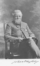
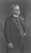
In 1871 the two brothers John and Robert Naylor walked from John o'Groats to Lands end staying the nights in temperance hotels wherever possible and going to church on Sundays. This was probably the first time the walk was done.
John later arranged for the building of a Temperance Hall in Weaste Lane nearly opposite to the entrance to the Cuerdon estate.
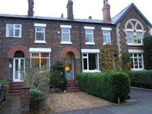
When this eventually fell out of use it was converted into a terraced row of four houses which now form desirable properties.
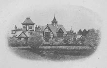
John also paid for the erection of the stone gateway to the Thelwall parish church yard and there are memorials to him there. When he retired he built a large house at Tarporley called Beeston Towers. As the Naylors were in the timber trade, the house was built almost entirely of wood. It is now a hotel and carved wooden representations of the two brothers can be seen in the main dining room.
Weaste Lane runs along the southern border of the parish of Thelwall in Cheshire from the junction with Booths Lane to the boundary of Grappenhall parish at Cliff Lane.
As shown in early cottage rent books and historic maps, it was originally called "Waste Lane" and this pronunciation is still used by old residents.
In medieval times the term "waste" referred to land which was outside the cultivated area or parish boundary and therefore had no owner. This seems to be appropriate as the lane well away from the centre of the village and still has open fields to the south which have escaped modern development.
As this is an agricultural area the lane has five farms along its length, some of which have been converted for other purposes. The oldest of these was called Garland Hall in times gone by but, at the time of its demolition was the farmhouse lived in by the Stubbs family, well known farmers in the area.
It was constructed with massive wooden beams in a general style similar to the ancient Pickering Arms in the centre of the Thelwall village. The walls between the beams were yellow and my impression of them was that they were original wattle and daub. This would seem to mean that Weaste Lane was at least as old as the early eighteenth century and probably earlier.
It remained a trackway connecting the farms for many years until Francis Edgerton Third Duke of Bridgewater engaged James Brindley to extend his canal system from Manchester to Runcorn in order to carry coal from his mines at Worsley.
The Bridgewater canal which was built in 1772 had no locks and followed the contours of the land as far as possible. Brindley's plan meant that it crossed the line of Weaste Lane at its western end. The lane therefore had to be diverted to run along side the canal which here is on a raised earth embankment. The short length of the lane which was cut off was incorporated into the entrance drive to Thelwall Heyes, a large country house.
The new junction of Weaste Lane with Cliffe Lane which was formed proved to be a suitable site for a tannery. Easy access to the canal was provided by a sloping ramp up which fresh cattle hides and finished leather could be transported. The tannery was later taken over by the Lancashire Co-op Society.
Round about the same time two terraced rows of cottages with a communal well were built in the lane. Each consisted of four houses one called Anderton Place, the other called Cuerdon Place. Behind them allotments stretched down to the canal, each one large enough to make its associated cottage self sufficient in fruit and vegetables. These provided accommodation for tannery workers and farm labourers.
In 1853 Thelwall railway station opened on the Warrington to Stockport Line. The station was in Half Acre Lane only a short distance from Weaste Lane. The area became a convenient place for wealthy businessmen from Warrington to build their houses.
Sir Peter Rylands was the most eminent of these industrialists. His house in Half Acre Lane was eventually left to the public for educational purposes and is now Massey Hall School. Another of these mansions is now the Grange Nursing Home.
Next to Stubbs's farm was a yellow brick mansion which throughout the 1940s gave the appearance of being partly demolished. I believe that this was the result of the owner, Thomas Glazebrook an eminent scientist, removing an astronomical obervatory from the side of the building and transporting it to Liverpool.
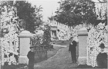
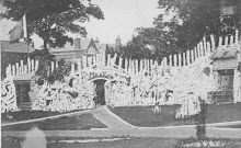
The Cuerdon Estate which, like the tannery next to it, is now covered by modern housing . Cuerdon mansion was demolished in about 1937. It was known locally as "Oyster Shell Hall" because the front was decorated with shells. Unlike the other mansions in the lane, Cuerdon was an 18th Century estate which at the time of its demolition included two lodge entrances, stables, a dairy house, a bothy for the accommodation of estate workers, an orchard, a boating lake and at least two houses in the grounds. The western part of the estate had been cut off by the Bridgewater canal making it smaller than it was originally.
In order to research the early history of the estate it would be necessary to locate early records if they exist. However, living in the mansion during the 19th century were the Naylor family, highly respected in the area as church-going supporters of the Temperance Movement.
In 1871 the two brothers John and Robert Naylor walked from John o'Groats to Lands end staying the nights in temperance hotels wherever possible and going to church on Sundays. This was probably the first time the walk was done.
John later arranged for the building of a Temperance Hall in Weaste Lane nearly opposite to the entrance to the Cuerdon estate.
When this eventually fell out of use it was converted into a terraced row of four houses which now form desirable properties.
John also paid for the erection of the stone gateway to the Thelwall parish church yard and there are memorials to him there. When he retired he built a large house at Tarporley called Beeston Towers. As the Naylors were in the timber trade, the house was built almost entirely of wood. It is now a hotel and carved wooden representations of the two brothers can be seen in the main dining room.